Artificial Intelligence
Why AI Failed During the 2025 Texas Floods: Key Lessons for Disaster Management
In July 2025, Texas experienced one of the most severe floods in its history. The disaster claimed more than 145 lives and caused damage worth billions of dollars. Many communities were unprepared for the speed and force of the rising waters. This happened despite widespread belief in the ability of Artificial Intelligence (AI) to predict and manage such events.
For years, AI has been presented as a vital solution for anticipating extreme weather. Governments and experts have relied on it to improve early warning systems. However, during this crisis, the technology did not perform as expected. This incident shows that while AI offers many benefits, it also has limitations. These limits must be clearly understood and addressed to improve public safety in the face of future climate-related emergencies.
The Texas Floods of 2025: A Wake-Up Call
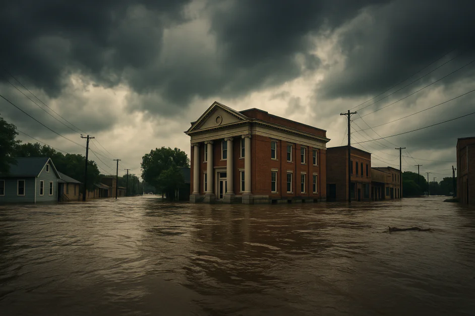
On July 4, 2025, Central Texas faced one of the deadliest inland floods in recent U.S. history. Known as part of Flash Flood Alley, the region had already seen days of heavy rainfall. But on this day, conditions worsened quickly. In just a few hours, the Guadalupe River rose sharply from less than 3 feet to over 34 feet in some areas. The water broke through its banks and swept away homes, vehicles, and lives.
A rare mix of weather conditions caused the disaster—moisture from the remnants of Tropical Storm Barry combined with other storms moving across the area. The region’s soil, already hardened by drought, could not absorb the sudden downpour. As a result, more than 10 inches of rain fell in some places within just three hours. Few people in the area had ever seen rainfall of this intensity.
Communities such as Kerrville were hit the hardest. At least 135 people died, including 37 children and staff members from Camp Mystic, a summer camp located along the river. Entire neighborhoods were flooded. Many businesses were damaged or destroyed. Roads, bridges, and critical infrastructure collapsed. Experts estimate the total losses between $18 billion and $22 billion, making it one of the most expensive natural disasters in the region’s history.
Emergency services were overwhelmed. The National Weather Service issued over 22 alerts and flood warnings the day before. But the water rose too fast. In some areas, forecasts from different models gave mixed results. This caused confusion and delayed some evacuation decisions. In several towns, emergency sirens failed to work. Many people were not given sufficient warning in time. Power failures and mobile network issues also made it hard for rescuers to reach people or share information.
During the crisis, platforms like X (formerly Twitter) became key sources of updates. People posted videos and asked for help. Volunteers used these messages to organize rescue efforts. However, many posts were not verified. This led to confusion and sometimes spread false information.
The 2025 floods highlighted significant shortcomings in the state’s disaster response system. Forecasting tools did not keep pace with the storm’s speed; communication failures and a lack of coordination further exacerbated the damage. The tragedy highlighted the need for improved early warning systems, enhanced planning, and more reliable infrastructure to protect vulnerable communities in the future.
Why AI Could Not Predict the Texas Floods Properly
The floods in Texas during July 2025 showed that AI systems are still far from perfect. These systems failed to provide clear and early warnings. Many technical and human problems came together. These included missing data, weak models, poor communication, and limited use of AI by emergency teams. The issues are discussed below:
Weak Data and Missing Information
Accurate and timely data is essential for AI to predict floods effectively. During the July 2025 Texas floods, many small watersheds in Central Texas lacked sufficient sensors. In some places, stream gauges failed or reached their maximum limit due to extreme conditions. This made it hard to collect reliable data during the most critical hours.
NASA’s SMAP satellite provides useful soil moisture data, but its resolution, ranging from 9 to 36 kilometers, is too coarse for local flood prediction. Earlier, SMAP had a radar sensor that offered higher resolution, ranging from 1 to 3 kilometers. It stopped working in 2015. Now, only the radiometer is used, which cannot detect fast, small-scale changes. This is a significant gap in places like Central Texas, where flash floods can vary within just one kilometer. Without fine-grained data, AI tools struggle to give accurate and early flood warnings.
Weather radar systems also struggled during the Texas floods. Heavy rain in hilly areas caused signal loss and scattering, which reduced the accuracy of rainfall readings. This created blind spots that affected both traditional and AI-based flood forecasts.
Platforms like Google Flood Hub combine satellite images, radar data, sensor inputs, and past flood records. But without real-time local data from stream gauges and sensors, these systems lose accuracy. During the 2025 floods, many data sources were not fully connected. Satellite, radar, and ground sensor data were often processed separately, resulting in delays and poor coordination. This limited the AI’s ability to track the flood in real-time.
AI tools need fast, complete, and well-integrated data. In this case, missing and unsynchronized inputs made it hard for them to predict how the flood would unfold.
AI Models Were Not Ready for Extreme Rainfall
The July 2025 floods in Texas exposed significant gaps in both traditional and AI-based forecasting systems. In parts of Central Texas, more than 10 inches of rain fell within a three-hour period. At its peak, the rain reached 4 inches per hour. Meteorologists described this as a 500-year flood, an event with a 0.2% chance of occurring in any given year.
Most AI models used for weather and flood prediction are trained on past data. They work well when the weather follows known patterns. But they often fail during extreme or rare events. These are called out-of-distribution events. The Texas flood was one such event. The models had not seen anything like it before, so their predictions were inaccurate or late.
Other problems made things worse. The region had faced drought, so the dry soil could not absorb water quickly. The hilly terrain increased runoff. Rivers rose fast and overflowed. Physics-based models can simulate such complex situations. But many AI models cannot. They lack physical reasoning and sometimes yield results that appear correct but are not realistic.
Communication and Alert Systems Did Not Work Well
AI predictions only help when they are delivered clearly and on time. In Texas, this did not happen. The National Weather Service (NWS) utilized models, such as the High-Resolution Rapid Refresh (HRRR), which predicted heavy rain 48 hours before the floods. But the warnings were not clear. AI outputs showed grids and probabilities. Local officials needed simple alerts. Translating complex data into clear warnings remained a technical challenge.
Emergency alerts also failed. CodeRED, a phone-based system, needed manual activation. In some counties, this was delayed by 2 to 3 hours. Outdated software and weak integration with AI tools caused problems. AI models ran on cloud systems, but local agencies used older databases. These could not handle real-time data. In some instances, delays in data sharing exceeded 30 minutes.
Some private models did better. WindBorne, for example, uses high-altitude balloons to collect data. Its models gave better localized rain forecasts than NWS tools. However, the NWS was unable to use them in time. External models needed weeks of validation. There were also no standard APIs for fast data sharing. WindBorne’s data format did not match NWS systems. So even accurate forecasts remained unused during the emergency.
Human Problems Made Things Worse
Human factors added more technical problems. Emergency managers were overwhelmed with data. AI models generated various outputs, including rainfall maps and flood risk levels. These came from different sources, such as Google Flood Hub and NWS. Sometimes, predictions did not match. One system indicated a 60% flood risk, while another showed an 80% risk; this confusion delayed officials’ decisions.
Training was also a problem. Many local teams had little experience with AI. They could not understand complex model outputs. Deep learning systems, such as Flood Hub, were available, but there is no evidence that they were actively used or understood by local emergency teams during the crisis. Explainable AI tools, such as SHAP, which enhance interpretability, could have helped manage the situation more effectively.
Moreover, emergency personnel faced an overwhelming amount of information. They had to process AI-generated forecasts, radar images, and public alerts. The volume and inconsistency of this data contributed to delays in response and added to the confusion.
Lessons Learned and the Future of AI in Disaster Management
The Central Texas floods in July 2025 demonstrated the potential of AI in emergencies. At the same time, they revealed major weaknesses. While AI systems offered early warnings and forecasts, they often failed when it mattered most. To prepare better for future disasters, we must learn from this event. The key lessons are linked to data quality, model design, communication gaps, climate adaptation, and collaboration.
Weak Data Foundations Limit AI Accuracy
AI systems rely on real-time, high-quality data. In rural areas like Kerrville, there were few stream gauges. This left large blind spots. As a result, predictions failed to capture local flooding patterns. Satellite data helped, but it lacked detail. NASA’s SMAP sensor, for example, covers vast areas but at low resolution. Local ground sensors are needed to refine such data.
One solution is to expand sensor networks in high-risk areas. Another is to involve local communities. In Assam, India, local agencies have deployed mobile-based weather stations and piloted citizen reporting tools to improve coverage in flood-prone regions. A similar system in Texas could involve schools and local groups to report flood signs.
AI Models Need Real-World Reasoning
Most current AI models learn from patterns, not physics. They can predict rainfall but struggle to model real flood behavior accurately. Deep learning systems often fail to capture how rivers rise and overflow. During the Texas floods, some models under-predicted the water surge. This delayed key decisions.
Hybrid models are a better option. These combine AI with physics-based systems to improve realism and trust. For example, Google’s Flood Forecasting Initiative uses a hybrid approach that blends a Hydrologic Model (based on machine learning) with an Inundation Model (based on physical simulation). This system has demonstrated improved accuracy and lead-time reliability in riverine flood prediction across more than 100 countries.
Communication Gaps Made Things Worse
During the floods, AI systems produced useful forecasts. However, the information did not reach the right people on time. Many emergency teams were already under pressure. They received alerts from different systems. Some of the messages were confusing or even conflicting. This caused delays in taking action.
One major issue was the way information was shared. Some emergency workers were not trained to understand AI outputs. In many cases, the tools were available, but local teams lacked the proper knowledge to use them effectively.
There is a clear need for better communication tools. Alerts must be clear, concise, and easy to respond to. Japan uses short flood messages that include evacuation instructions. These alerts help reduce response time. A similar system can be helpful in Texas.
It is also essential to present AI forecasts through familiar platforms. For example, showing flood warnings on Google Maps can help more people understand the risk. This approach can support faster and safer decisions in emergencies.
Climate Extremes Are Breaking Old Models
The rainfall in 2025 broke many records. Most AI systems did not expect such intense weather. This happened because the models were trained on past data. However, past patterns no longer align with today’s climate.
To stay useful, AI must be updated more often. Training should include new climate scenarios and rare events. Global datasets, such as those from the IPCC, can help. Models should also be tested on extreme cases to verify their ability to handle future shocks.
Working Together Is Still a Challenge
Many organizations had useful tools during the crisis. However, they did not work together effectively. Important data was not shared on time. For example, WindBorne collected high-altitude balloon data that could improve flood forecasts. But this information was delayed due to technical issues and legal restrictions.
These gaps limited the full benefits of advanced systems. Public and private organizations often used separate models. There was no real-time connection between them. This made it harder to build a clear and complete picture of the situation.
To improve this, we need common data standards. Systems should be able to share information quickly and safely. Real-time coordination between different models is also essential. Additionally, collecting feedback from local communities can help make systems more accurate and effective.
Technology Is Advancing, But Needs Support
New technologies can improve flood management. But they need proper infrastructure and policy support. One promising method is physics-informed AI. This combines scientific knowledge with machine learning to improve flood prediction. Research groups, such as those at MIT, have tested this approach to make forecasts more accurate and realistic. However, detailed results are not yet publicly available.
Other tools, such as drones and edge devices, also help. They can collect data in real time, even in areas where ground systems are damaged or missing. In the Netherlands, simple public dashboards show flood risk using clear visuals. This helps people understand the situation and take action quickly.
These examples demonstrate that advanced tools must also be user-friendly. They should be linked with public systems so that both experts and communities can benefit from the
The Bottom Line
Flood prediction is no longer just about weather maps and warnings. It now involves AI systems, satellite data, local reports, and rapid communication tools. However, the real challenge is not just building smarter tools—but making sure they are used effectively by people on the ground.
The 2024 Texas floods demonstrated how delays, poor coordination, and unclear alerts can negate the benefits of advanced technology. To improve, we need clear policies, shared systems, and tools that local teams can understand and act on quickly.
Countries like Japan and the Netherlands show that it’s possible to combine intelligent forecasting with easy public access. AI should not only predict floods, but it must also help prevent damage and save lives. The future of flood management depends on combining innovation with action, technology with trust, and intelligence with local readiness. This balance will define how well we adapt to rising climate risks.


